Jump to Content
Secondary menu
Media Center
Calendar
Log in
Search form
Search
Basin
Fast Facts
What is a watershed?
Watersheds Across Scales
Minnesota River Profile
Minnesota River Virtual Tour
History
Timeline
Steamboating
Place Names
Historic Images
Geology
Glaciation
Valley Formation
Hydrology
Flooding
Landscape & Wildlife
Bird Photos
Fish Photos
Mammal Photos
Prairies
Wetlands
What is it?
River Stories
Art & Barb Straub
Bob Smith
Brand Frentz & Joe Michel
Charles Smith
Dave Craigmile
Del & Shirley Wehrspann
John Fritsche
Richard Handeen & Audrey Arner
close this panel
Watersheds
Blue Earth
Chippewa
Cottonwood
Hawk Creek - Yellow Medicine
Lac qui Parle
Le Sueur
Lower Minnesota
Middle Minnesota
Pomme de Terre
Redwood
Upper Minnesota
Watonwan
close this panel
Reports
close this panel
Maps & GIS
Printable Maps
Basin Maps
Watershed Overview Maps
Land Use Maps
Impaired Waters Maps
Interactive Maps
Ask An Expert 360° Virtual Tours
Geologic Atlas - 13 County
Minnesota Tillage Transect Survey Data Center
Surface Water Hydrology Atlas - 13 County
Southern MN Tile Monitoring Project
close this panel
Make a Difference
Restoration
In the City
On the Farm
Water Storage
Get Involved
Nonprofit Organizations
Watershed Districts
Watershed Projects
State-wide Groups
National Groups
Universities & Colleges
American Indian Com.
SWCDs
close this panel
Explore
Mystery / Intriguing Sites
Historical / Cultural Sites
Fishing
Swimming
Paddling
Camping
Hiking
Biking
Horseback Riding
Bird Watching
Hunting
close this panel
Water Quality
WQ Overview
Monitoring
Monitoring Data
Impaired Waters
Pollutants
Trends Report
State of the Minnesota River
Progress Report
Downtream Impacts
Minnesota to Mississippi
close this panel
Learn
Meet the Experts
Landscape History
Geology
Prairies
Wetlands
Landscape Today
Agriculture
Water Quality
Monitoring
Impaired Waters
Sediment
Phosphorus
Nitrogen
Downstream Impacts
Bio-Indicators
Fish
Mussels
Macroinvertebrates
Making a Difference
Pollution Problems
Clean Up Solutions
Case Studies
Voices of the River
close this panel
You are here
Home
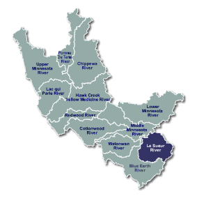
Le Sueur
Primary tabs
View
(active tab)
View
(active tab)
Blue Earth County Envrionmental Services Office
read more
Blue Earth County Soil and Water Conservation District
read more
Table 1.LE. Le Sueur River Monitoring Station Information
Offerman, Heather
Source:
Link
Watershed(s):
Le Sueur
Keywords:
Le Sueur River Monitoring
Water Quality
Monitoring Station Report
read more
Evaluation of an ELISA Method for Acetochlor Analysis in the Le Sueur River Watershed
VanRyswyk, Bill
Source:
Link
Watershed(s):
Le Sueur
Keywords:
ELISA Method
Le Sueur River Watershed
Acetochlor Analysis
read more
Minnesota River Basin: Watonwan, Blue Earth, and Le Sueur River Watersheds
MPCA
Source:
Link
Watershed(s):
Blue Earth
Watonwan
Le Sueur
Keywords:
Blue Earth Watershed
Watonwan Watershed
Le Sueur Watershed
read more
Place Names - Le Sueur River
Watershed regions:
Le Sueur
Le Sueur River
The Le Su
read more