Printable Maps
Watersheds are Everywhere
Stand anywhere on the surface of planet Earth and you're standing in a watershed. Water falling to the ground as precipitation is absorbed into the soil--becoming groundwater--and drains from the surface of the land into the nearest creek or stream. Streams join other streams and flow into rivers which, in turn, are fed by the groundwater through underwater springs. All of the area that drains into each creek, stream, or river is called its watershed.
The following links will take you to galleries of Printable Basin and Watershed Maps (Overview, Land Use, and Impaired Waters Maps). View the thumbnails in larger view by clicking on them or download a full resolution pdf of the map by clicking on the link below the image.
BASIN MAPS
The following maps were created for the Minnesota River Blueway Project (current to 2013).
Minnesota River Basin - Conservation Lands
Minnesota River Basin - Geology
Minnesota River Basin - Impaired Waters
Minnesota River Basin - Land Use
Minnesota River Basin - Major Watersheds
Minnesota River Basin - Blueway Partners
Minnesota River Basin - Recreation
Minnesota River Basin - Riparian Zone Connectivity
Minnesota River Basin - Federal Congressional Districts
Minnesota River Basin - State Legislative Districts
WATERSHED MAPS
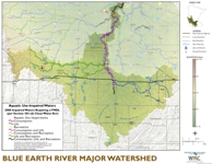
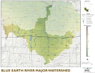
Watershed Overview Maps
Land Use Maps

Impaired Waters Maps