Minnesota River Virtual Tour - Mankato
|
|
|||||
|
Stop 8 - Mankato & North Mankato (River Mile 114) |
|||||
 |
 |
||||
 |
|||||
|
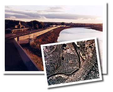
As we move closer to Mankato, the river becomes lazier. There are very long straight stretches with slow meandering curves, and the channel is wide. Up ahead we see the floodwalls of Mankato and the bend in the river. We're about to turn northeast and finish the last leg of our voyage. |
|||||
|
Bend in the River Near the cities of Mankato and North Mankato, the river takes a distinctive turn to the northeast. The creation of this famous bend is attributed to the glacial River Warren flood waters hitting bedrock around Mankato and being forced northeast towards what is now the Twin Cities. Flooding Generally speaking, a flood is a high flow that overtops a stream's natural channel—a natural event in watersheds. In terms of the river as a natural system, floods can have beneficial effects such as scouring debris from the channel and depositing rich sediments on the floodplain. If the area is inhabited, however, floods can also cause extensive damage. Mankato and North Mankato are examples of many river communities in the basin that have a long flooding history. Dakota Chief Sleepy Eye is credited for the current location of the city. Early traders built a post in the floodplain near the junction of the Blue Earth and Minnesota Rivers in what is now Sibley Park. Sleepy Eye warned the traders that it was a hazardous place for a permanent settlement because the river periodically flooded. The traders moved their post away from the river and up to a higher elevation—to present day Front Street. The Mankato townsite developed nearby. However, even this higher elevation proved to be problematic. Historic records show significant floods in 1881 and 1908. A series of massive floods in 1951, 1961, and 1965 triggered the construction of the floodwalls that line the river today. These floodwalls serve as a reminder. While the river might look calm flowing through town, the river could rise again to flood stage. |
|||||
| | map | 1 | 2 | 3 | 4 | 5 | 6 | 7 | 8 | 9 | 10 | 11 | 12 | basin overview | home | |
|
||||