Minnesota River Virtual Tour - Map
|
|
|
|
|
 |
|
|
|
|
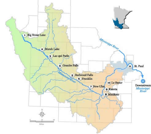
As we head downriver, we’ll be exploring stops along the 335-mile journey of the Minnesota River. We'll start at the headwaters near Big Stone Lake (1) and continue on to the confluence with the Mississippi River near St. Paul, Minnesota (11). As part of the larger Mississippi River basin (map), water from the Minnesota River ultimately flows into the Gulf of Mexico (12). The Minnesota River Basin is a large watershed that drains roughly 20 percent of the state. This tour was inspired by the canoe journey documented in Mankato's The Free Press newspaper. Journalist Tim Krohn's reflections are included (in italics) at each stop and John Cross' photographs are woven throughout. Click on any web image to see a larger view. You can navigate the tour by either clicking on the map or the links at the bottom of the page. Many thanks to these and other contributors to the tour (virtual tour credits). |
|
|
|
|
|
|
|
