Minnesota River Virtual Tour - Granite Falls
Stop 4 - Granite Falls (River Mile 253) |
|||||||||
 |
 |
||||||||
 |
|||||||||
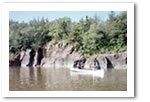
From Granite Falls down through Morton, the pitch of the land falls more quickly than other places along the river. That drop in elevation is evident on the river as the current gains momentum. Soon, we turn a bend in the river to see granite boulders the size of school buses littering the shoreline. Further down, massive outcroppings of rainbow granite and black granite tower up the banks of the river. The sheer walls of the granite are both awesome and intimidating. |
|||||||||
Rapids From Granite Falls to Morton the Minnesota flows through an area of granite outcrops (photo, right). This area is rugged and quite different from the rest of the basin. In some places sheer granite bluffs plunge into cloudy water. You will encounter the river's only sets of rapids as well as two natural waterfalls near the city of Granite Falls (above). Look out for Patterson’s Rapids at RM 226—a stretch of white water tumbling over a bed of boulders. Patterson’s Rapids As we turned a bend, some 20 miles downstream from Granite Falls, we saw the rapids. Patterson’s Rapids looked more like the giant whitecaps that broil across a large lake in high winds. As we drifted closer, we picked a route to the left where the water ran smoother. It wasn’t until we got close—very close that we realized why the water looked smooth here. It was a mini waterfalls, the water dropping about 3 feet, creating a trough of whitewater that we couldn’t see upriver. |
|||||||||
 |
|||||||||
 |
|||||||||
| | map | 1 | 2 | 3 | 4 | 5 | 6 | 7 | 8 | 9 | 10 | 11 | 12 | basin overview | home | |
|
||||||||