Water Storage Multiple Benefits
Photo credit: Water Resources Center MNSU – Mankato, 2012, CMM Pollinator Site
There are multiple benefits to using water storage as a conservation practice: reducing peak flows, nitrogen reduction, sediment settling, and increased habitat for many diverse species that live in and around water.
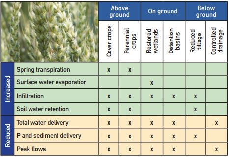
Some of these multiple benefits are summarized in the Minnesota Public Drainage Manual created by BWSR: https://drainage.pca.state.mn.us/index.php/BMP_Table.
REDUCING PEAK FLOWS
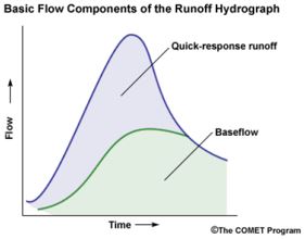
Photo Credit: Sitterson, J., Knightes, C., Parmar, R., Wolfe, K., Muche, M., and Avant, B., 2017, An Overview of Rainfall-Runoff Model Types, Environmental Protection Agency, Office of Research and Development, National Exposure Research Laboratory, Athens, GA, p 10.
Reducing peak flows of rivers is a primary benefit of water storage. While increasing rain and altered hydrology are adding to the river’s volume, the timing of when water reaches the water body is another important consideration. Because of altered hydrology, the landscape is much more directly connected to the rivers than it was historically. Today it takes less time for rain to reach the river. This shortened time period increases flood frequency in many towns and rural areas throughout the region. One way to decrease these peaks in flooding is targeted water storage. Within a watershed there are certain strategic areas where placing water storage could reduce peak flows (see map below). Hydrologic modeling can help identify targeted areas. Several examples of travel time maps are the Red River Basin, and River Park Drive Subwatershed within the Le Sueur River Watershed of the Minnesota River Basin.
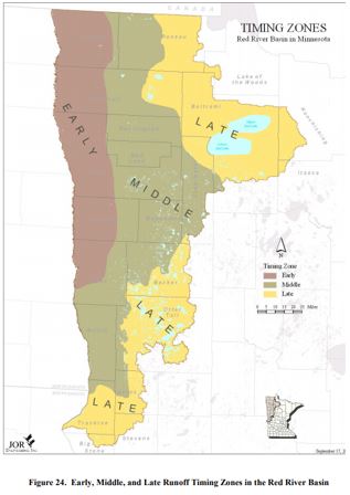
Anderson, C., and Kean, A., 2004, Red River Basin Flood Damage Reduction Framework: Red River Basin Flood Damage Reduction Work Group Technical and Scientific Advisory Committee Technical Paper No. 11, 53 p., http://www.rrwmb.org/TSAC/TP11.pdf.
This map shows the timing of when rain would reach the Red River. If water storage was added to the “middle” range of the map, peak flows could be reduced in the Red River. Time analysis can be done with any modeled watershed using the PTMApp, and can be supported by other programs such as ACPF, to find the ideal locations in a watershed to reducing peak flows.
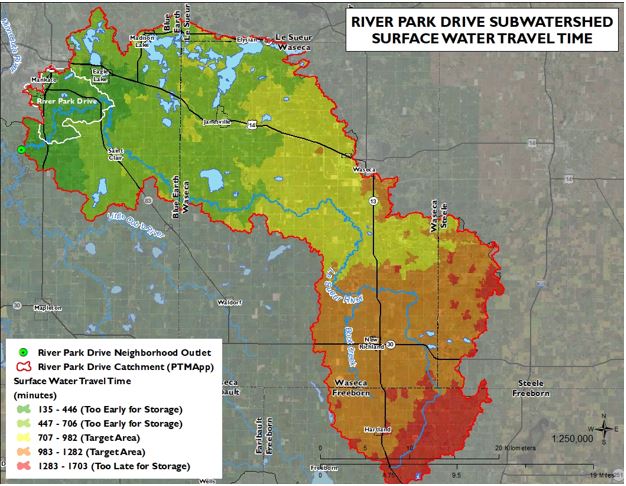
Map illustrates water travel times and potential locations for water storage placement within the River Park Drive Subwatershed of the Le Sueur River Watershed. Travel times and the relationship to effective water storage placement within the River Park Drive Subwatershed. The map was created using the PTMApp ArcGIS application. Map courtesy of Tyler Grupa at the Water Resources Center, MNSU – Mankato,
INCREASING HABITAT
Different water storage practices can also increase habitat for various species. The most well-studied water storage practice for increasing habitat are wetlands. However pollinator friendly plants can be used in conjunction with soil health practices or rain gardens for increased water retention and storage. While there is limited research in Minnesota, in Colorado, beavers are being used to increase water storage and create habitat for other species. Many ideas are out there, but we can all do something to increase native plant and animal habitat.
More Resources:
Wetlands
https://www.blueearthcountymn.gov/1117/Water-Storage
https://www.epa.gov/wetlands/why-are-wetlands-important
https://www.pca.state.mn.us/water/threats-minnesotas-wetlands
Beavers
Pollinators
https://www.pca.state.mn.us/featured/bring-back-pollinators
https://files.dnr.state.mn.us/natural_resources/npc/2014_draft_pollinator_bmp_guidelines.pdf
https://www.cleanwatermn.org/roots-return-farm/
http://www.metroblooms.org/bloomsblog/planting-for-pollinators-how-raingardens-can-help/
Cover crops for wildlife
https://bwsr.state.mn.us/cover-crops-wildlife
US Fish & Wildlife easement manual
https://ecos.fws.gov/ServCat/DownloadFile/15431?Reference=15841
IMPROVING WATER QUALITY
Many water storage practices also improve water quality, depending on the particular practice.
July 2016, Freshwater Society under a grant from the LMRWD. 2424 Territorial Road, Suite B, Saint Paul, MN 55114, Principle authors: Carrie Jennings, PG, Ph.D., Brian Bohman, Peggy Knapp, Edd, https://freshwater.org/wp-content/uploads/2019/05/ChangeInMinnRiverReport_8.5x11_rev5.19.pdf.
The plants in wetlands, detention basins and permanent crop cover have the potential to reduce nutrients and sediment reaching the rivers, in strategic locations combined with specialized implementations. This can help reduce the number of rivers on the impaired waters list at the MPCA. The key for many of these practices is continual management to continue the effectiveness. Much of these impacts are studied in TMDL and WRAPS reports from the MPCA, which are currently being used to inform One Watershed One Plan watershed plans that are being implemented throughout the state. For more information on the Minnesota River Basin science and water quality from the MPCA: https://www.pca.state.mn.us/water/minnesota-river-basin
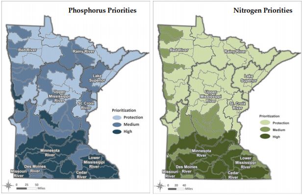
Many studies are revealing that cover and perennial crops could be an essential part of any farm to reduce loss of nutrients to water systems. These cover and perennial cropping systems can trap the nutrients that are placed on the farm to help the cash crops grow and reduce what percentage of the fertilizers are leaving the farm and cutting costs. Adding cover crops to the landscape, with high priority in the Minnesota River Basin is an essential part of the Minnesota Nutrient Reduction Strategy, a coordinated effort of 9 federal and state agencies, and the University of Minnesota Extension.
Minnesota Pollution Control Agency, 2014, Minnesota Nutrient Reduction Strategy: https://www.pca.state.mn.us/sites/default/files/wq-s1-80.pdf
More Resources:
Minnesota Nutrient Reduction Strategy Executive Summary
https://www.pca.state.mn.us/sites/default/files/wq-s1-80a.pdf
2-page summary of Minnesota Nutrient Reduction Strategy
https://www.pca.state.mn.us/sites/default/files/wq-s1-80q.pdf
Wetlands
http://www.jswconline.org/content/55/3/303.short
https://www.extension.purdue.edu/extmedia/WQ/WQ-10.html
Wetlands in agricultural lands
http://biogeochemistry.nres.illinois.edu/pdfs/Kovacic%20et%20al%20JEQ%202000.pdf
https://www.nature.com/articles/s41561-017-0056-6
Wetlands in Minnesota
https://www.nature.com/articles/s41561-017-0056-6
Detention Basins
https://cfpub.epa.gov/si/si_public_record_report.cfm?Lab=NHSRC&dirEntryId=343094
https://onlinelibrary.wiley.com/doi/full/10.1111/jawr.12223
https://www.pca.state.mn.us/sites/default/files/swm-ch5.pdf
http://www.allianceofrougecommunities.com/PDFs/PI/FINALdetentionbasinmanual.pdf
Crop cover
https://extension.umn.edu/soil-and-water/cover-crops
https://www.pca.state.mn.us/water/nutrient-reduction-strategy


