Water Storage Geologic History
Photo credit: Google Maps, Imagery: ©2019 Landsat/Copernicus, NOAA; Map data: ©2019 Google
The Minnesota River Basin was formed over the last several hundreds of thousands of years from the repeated advance of the Laurentian Ice Sheet which left large lateral and end moraine1 deposits that formed into the boundaries of the basin as we know it today. The final advance from the Des Moines lobe created Lake Agassiz as it retreated into Canada. The flooding of Lake Agassiz into Glacial River Warren cut through the many layers of till deposited from previous advances of Laurentian Ice Sheet. After the last major flood the area was split in what is now Traverse Gap on the border of Minnesota and South Dakota; where, north of the gap, Lake Traverse flows into the Red River of the North and ultimately Hudson Bay; south of the gap, Big Stone Lake flows into the Minnesota River and ultimately the Gulf of Mexico. Since that time the smaller Minnesota River has carved into the larger glacial valley feature to create the Minnesota River Valley. The river valley displays many terrace2 layers showing the downcutting3 over time. The two valleys have an important role in how water flows through the region and ultimately into the Minnesota River.
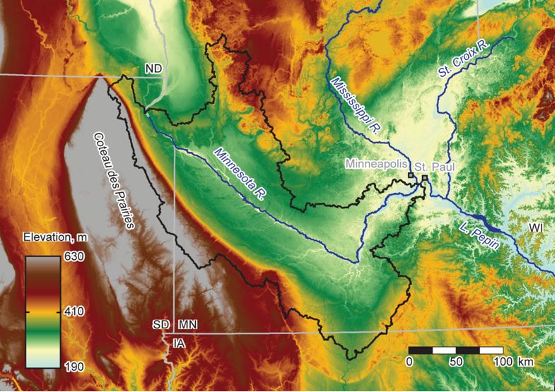
Photo credit: Dr. Karen Gran – Hydrology, geomorphology, and the need for water storage: Water Storage Forum presentation on April 4th, 2019
The downcutting of the Minnesota River has created a unique landscape that can be divided into streambanks and uplands. In the streambank areas there is direct connectivity to the floodplain and river, whereas upland areas drain to tributaries that flow into the Minnesota River. These tributaries are actively downcutting into the upland areas, creating ravines along the way. The uplands are relatively flat and contain Minnesota’s most fertile soil, created from the wetlands and prairie the existed on top of till for thousands of years before settlement of the region. During this time the uplands were much less connected to the floodplain than they are today due to how humans have changed the landscape through development and farming. This increasing connection to the floodplain and rivers comes with an increase in volume in the rivers, causing flooding and land erosion.
More resources:

University of Minnesota on Glacial Lake Agassiz
https://www.esci.umn.edu/sites/www.esci.umn.edu/files/REVIEW%20OF%20LAKE%20AGASSIZ%20HISTORY.pdf
1. The till deposited to the side and ends of a glacier during advance and retreat. (lateral moraine – “(a) A low ridgelike moraine carried on, or deposited at or near, the side margin of a mountain glacier. It is composed chiefly of rock fragments loosened from the valley walls by glacial abrasion and plucking, or fallen onto the ice from the bordering slopes. (b) An end moraine built along the side margin of a glacial lobe occupying a valley.”, Bates, R. L., and Jackson, J. A., 1987, Glossary of Geology: Alexandria, Virginia, American Geological Institute, 370 p. ; moraine – “A mound, ridge, or other distinct accumulation of unsorted, unstratified glacial drift, predominately till, deposited chiefly by direct action of glacier ice, in a variety of topographic landforms that are independent of control by the surface on which the drift lies.”, Bates, R. L., and Jackson, J. A., 1987, Glossary of Geology: Alexandria, Virginia, American Geological Institute, 432 p. ; end moraine – “A ridgelike accumulation that is being produced at the margin of an actively flowing glacier at any given time; a moraine that has been deposited at the lower or outer end of a glacier.” , Bates, R. L., and Jackson, J. A., 1987, Glossary of Geology: Alexandria, Virginia, American Geological Institute, 213 p. )
2. An old floodplain deposit that has been cut off from the current floodplain. (terrace – “(a) Any long, narrow, relatively level or gently inclined surface, generally less broad than a plain, bounded along one edge by a steeper descending slope and along the other by a steeper ascending slope; a large bench or steplike ledge breaking the continuity of a slope… A terrace commonly occurs along the margin and above the level of a body of water, marking a former water level.” , Bates, R. L., and Jackson, J. A., 1987, Glossary of Geology: Alexandria, Virginia, American Geological Institute, 679 p. )
3. A river’s continual downward erosion to reach a stable water level. This process occurs until a river has reached sea level. (“downcutting - Stream erosion in which the cutting is directed in a downward direction (as opposed to lateral erosion).”, Bates, R. L., and Jackson, J. A., 1987, Glossary of Geology: Alexandria, Virginia, American Geological Institute, 195 p. )