State of the Minnesota River 2002 Surface Water Quality Monitoring
STATE OF THE MINNESOTA RIVEREXECUTIVE SUMMARY SURFACE WATER QUALITY MONITORING 2002 Access the full 2002 State of the Minnesota River Report More on how to download and view pdf files |
 |
|
|
Basin Overview |
|
|
| This executive summary provides an overview of the more detailed report entitled State of the Minnesota River: Summary of Surface Water Quality Monitoring 2002. The 2002 full report consolidates surface water quality monitoring information collected in the Minnesota River Basin for calendar years 2000, 2001 and 2002. The report assembles data collected by multiple agencies and organizations and presents the data in a fashion that allows for relative comparison between the mainstem Minnesota River sites as well as the major and minor tributaries in the Minnesota River Basin. You can access the full report on the Minnesota River Basin Data Center website at http://mrbdc.mnsu.edu | ||
| BASIN OVERVIEW | ||
 |
The Minnesota River has been cited as one of the most polluted rivers in the state and nation. In response to these pronouncements, considerable attention and support have been given to clean up efforts. In recent years, there have been significant improvements in point source pollution control as well as continued adoption of conservation and best management practices within the Minnesota River Basin. With these changes has come an increasing expectation that the monitoring data being collected will or can be used not only to identify potential problem areas but also to quantify the impact of these changes on water quality. This collaborative effort will serve as a foundation for gauging progress toward a cleaner Minnesota River. The Minnesota River originates at the Minnesota-South Dakota border, flows for 335 miles through some of the richest agricultural land in Minnesota and joins the Mississippi River at Minneapolis/St. Paul. The river drains a basin of 16,770 square miles: 14,840 square miles in Minnesota, including all or parts of 37 counties; 1,610 square miles in South Dakota; and 320 square miles in North Dakota and Iowa. Minnesota’s portion of the basin is primarily used for agriculture and represents 18.5% of the state’s land mass and 29% of its cultivated land. As the state’s largest tributary of the Mississippi River, the Minnesota River’s volume increases the Mississippi’s flow by 57% and adds disproportionately to its pollutant load. Many water quality challenges relate to land uses including agricultural runoff and urban point-source discharges. While promising strides have been made to reduce point-source pollutants (like industrial and wastewater treatment plants), managing the array of nonpoint-source inputs marks the challenge ahead.
|
|
| MONITORING | ||
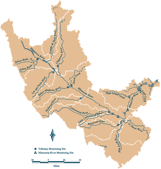 |
Monitoring History In many parts of the Basin, this information is used to target implementation practices that reduce nonpoint source pollution, thereby improving the overall health of the Minnesota River. Local watershed projects are supported by Clean Water Partnership grants administered by Minnesota Pollution Control Agency (MPCA). Much of the remaining data presented in this summary report is provided through monitoring programs of the Minnesota Department of Agriculture (MDA) and Metropolitan Council Environmental Services (MCES), with contributions from the United States Geological Survey (USGS), Minnesota Department of Natural Resources (MDNR) and the Minnesota State Climatology Office. See list of contributors on the back page. MonitoringLocations Monitoring Season Monitoring Focus |
|
| METHODS | ||
|
Methods |
||
| PRECIPITATION & RUNOFF | ||
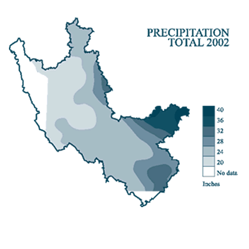   |
Precipitation Across the Basin, the amount of precipitation varies geographically, seasonally, and from year to year. In general, the eastern portion of the Basin receives more rain than the western. The 2002 total precipitation map (at right) illustrates that overall totals increase as one moves eastward through the Basin. Total precipitation amounts ranged from 20 inches in the western part of the Basin to over 40 inches in portions of the eastern. The general pattern is consistent with long-term rainfall distribution in the Minnesota River Basin. Runoff Runoff during the 2002 monitoring season varied from approximately 1 inch to greater then 11 inches. Watersheds in the western portion of the Basin exhibited lower runoff and those in the eastern portion of the Basin exhibited higher runoff. Evaluating runoff allows for a relative comparison of the amount of water coming out of different individual watersheds or portions of the basin. Higher runoff generally results in higher pollutant loads for most nonpoint source pollutants. The annual runoff graph (lower right) illustrates the trend of increasing runoff volume over the past several decades. Highly variable runoff from one monitoring season to another highlights the need for an on-going program that collects, analyzes, and reports on surface water quality monitoring data. |
|
| TOTAL SUSPENDED SOLIDS (TSS) | ||
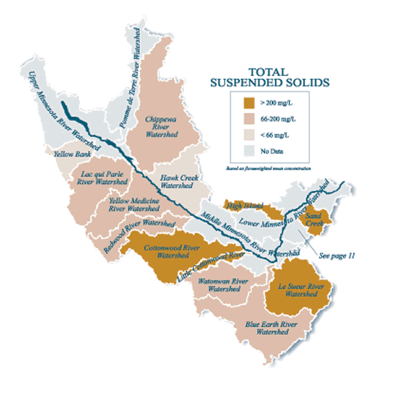 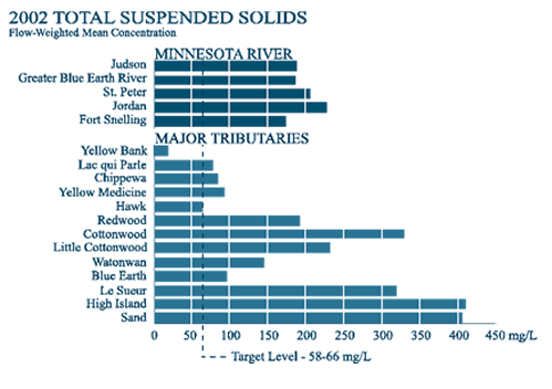 |
Total Suspended solids (TSS) 2002 Findings Mainstem flow-weighted mean concentration values during 2002 ranged from 172 mg/L at Ft. Snelling to 226 mg/L at the Jordan site. These values are substantially greater than the turbidity-based thresholds of 58-66 mg/L. Mainstem TSS loads in 2002 were substantially reduced from loads measured during 2001, reflecting less runoff during 2002 compared to the flood flows of 2001 |
|
| PHOSPHORUS | ||
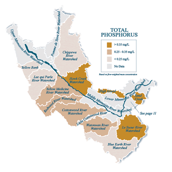 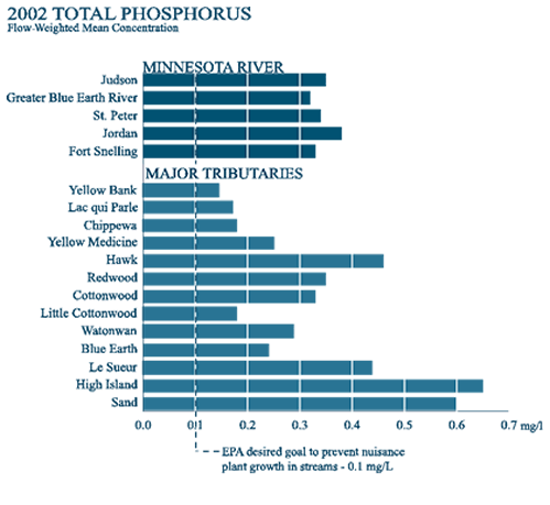 |
Phosphorus 2002 Findings Total phosphorus is an issue in all major tributaries. During 2002, the bulk of total phosphorus loading from tributaries occurred in the watersheds located in the middle and lower Minnesota River Basin (i.e. downstream of Morton). Because total phosphorus loading is strongly correlated with stream flow, year-to-year variability in runoff quantities explains much of the variability in TP loading. |
|
| ORTHOPHOSPHORUS | ||
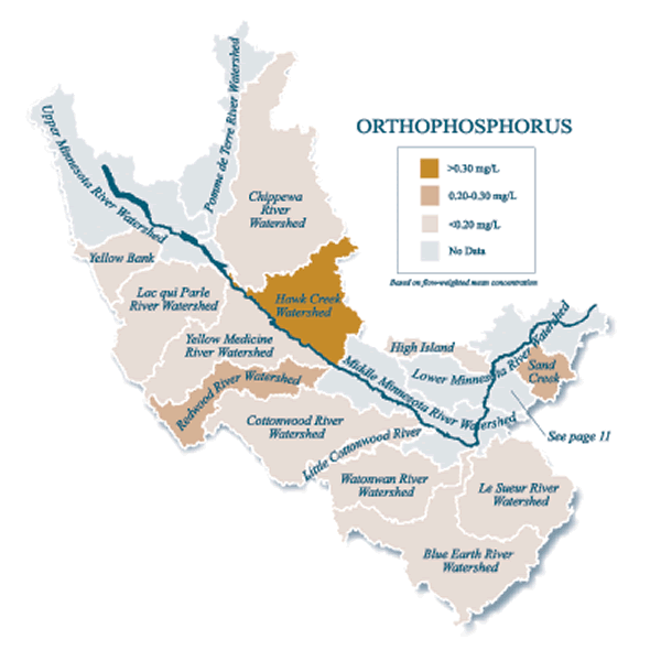 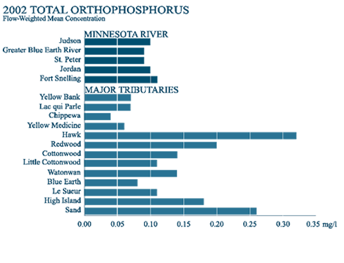 |
Orthophosphorus Orthophosphorus (OP), or soluble reactive phosphorus, is the primary form of phosphorus used by algae or other aquatic plants. Therefore, it provides a measure of the phosphorus immediately available for plant growth. Total phosphorus, by contrast, is a measure of the total concentration of phosphorus present in a water sample and includes phosphorus bound to sediment and organic matter which may not be immediately available for biological uptake. The availability of phosphorus in streams, soils and sediments changes in response to a variety of environmental conditions. OP is a readily assimilated form of phosphorus that triggers excessive algal growth when it is present in elevated concentrations. Because of its availability for uptake by aquatic plants, orthophosphorus is of particular concern for rivers and lakes. 2002 Findings Orthophosphorus loads at mainstem sites during 2002 were substantially reduced compared to loads during 2001, a year of spring flooding. Orthophosphorus yields were also greatly reduced compared to yields during 2001. Orthophosphorus FWMC values during 2002 are mostly uniform at mainstem sites and fit into a relatively narrow range of approximately 0.09 - 0.10 mg/L. The relatively large increase in OP load at the Minnesota River at Judson site reflects increased loads in four major tributaries during 2002: Chippewa River, Hawk Creek, Redwood River, and Cottonwood River. Orthophosphorus FWMC values for Hawk Creek and the Redwood River are particularly elevated. In these watersheds, more than one half of the phosphorus load was in the OP form, which can be readily used by algae. Point sources may have influenced the concentrations as these watersheds each receive wastewater effluent from medium-sized municipalities. Among major tributaries in the Lower Minnesota River Watershed, OP yields were greatest from the High Island Creek and Sand Creek Watersheds. Focused attention and evaluation of the major-tributary watersheds may be warranted to determine why some yield more OP than others. |
|
| NITRATE-N | ||
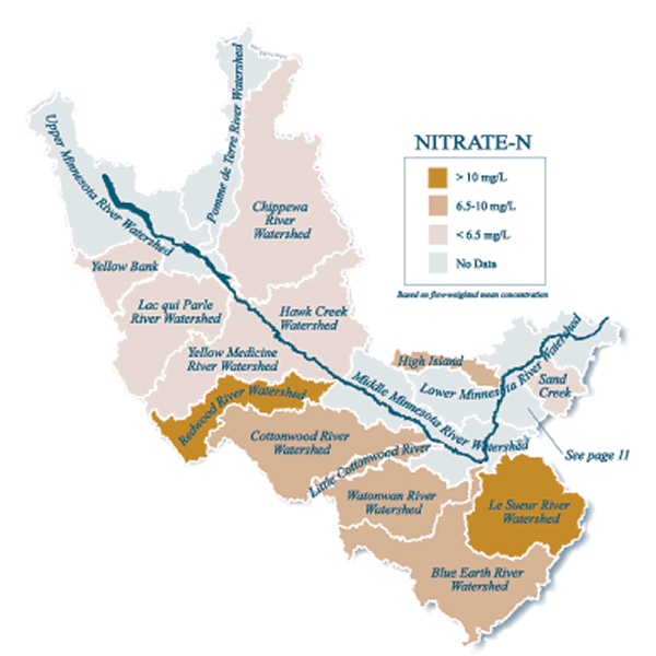 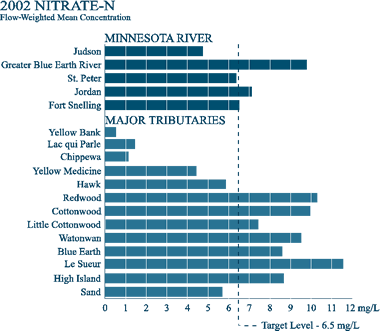 |
Nitrate-Nitrogen (Nitrate-N) The Greater Blue Earth (GBE) River stands out with the greatest FWMC values for nitrate-N. These values have been nearly constant during the three year period (9.78-9.95) despite substantial year-to-year differences in precipitation and runoff. The nitrate-N laden water of the GBE River joins the Minnesota River at its confluence at Mankato, increasing the nitrate-N FWMC of the Minnesota River. Flow-weighted mean concentrations of nitrate-N are greater than, or very near, the 10 mg/L drinking water standard in several major tributaries starting at the Redwood River and continuing downstream. Concentrations in these tributaries stand in sharp contrast to tributaries in the upper part of the Basin where concentrations are much lower and they underscore the need for effective BMPs that can reduce nitrate-N in streams. |
|
| PESTICIDES | ||
 |
Pesticides The Minnesota Department of Agriculture (MDA) is the lead state agency for all aspects of pesticide and fertilizer environmental and regulatory functions (see box below). To better understand pesticide use in Minnesota, the MDA conducted surveys designed to get a better understanding of existing farm practices regarding agricultural inputs such as fertilizers, manures and pesticides. The surveys found corn and soybean acreage accounted for the majority of pesticide applications. Pesticides were applied to over 95% of the major crops found in the study sites. (For more information about the studies, see the MDA website http://www.mda.state.mn.us/appd/pesticides/pesticideuse.htm). The MDA Monitoring and Assessment Unit collected pesticide samples from the Le Sueur River at Highway 66, the Blue Earth River below the Rapidan Dam, and the Minnesota River at Judson. Samples have been collected during 2000, 2001, and 2002. Over the three-year period, the herbicides metolachlor, atrazine and acetochlor were the most frequently detected compounds in these rivers. These herbicides are typically applied to corn and soybean fields for general weed control. 2002 FindingsFrom 2000-2002, metolachlor was the most commonly detected pesticide with detections in approximately 82 percent of the surface water samples collected. During this same three year period atrazine and acetochlor were detected in 73 and 64 percent of the samples, respectively. Runoff-adjusted yields indicate that the Le Sueur River and the Minnesota River at Judson delivered approximately the same pesticide yield per inch of runoff (0.28 lbs). Both the Le Sueur and the Blue Earth Rivers yielded much less total pesticide per inch of runoff in 2002 than in the previous two years. As in the previous two years, the Le Sueur River Watershed displayed the highest cumulative pesticide yield at over 1.5 pounds per square mile. The percent land use in agricultural row crop for the Judson, Le Sueur and Blue Earth Watersheds were estimated at 60, 82 and 85 percent respectively. |
|
| MINOR TRIBUTARIES | ||
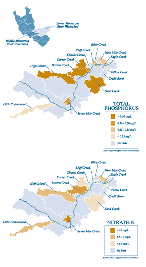 |
Minor Tributaries While this executive summary focuses on water quality trends for mainstem and major tributaries, the full report also provides a detailed discussion of minor tributaries. Minor tributaries are characterized by creeks that drain less than 100,000 acres. In 2002, data for 11 minor tributaries are included in the report. 2002 Findings Total Suspended Solids (TSS) - With the exception of Riley Creek, minor tributary watersheds where agriculture is the dominant land use exhibit considerably higher TSS flow-weighted mean concentrations when compared to the more mixed land use tributaries of the urban watersheds. Riley Creek, which had relatively high TSS yields during both 2001 and 2002, is a small watershed that is undergoing intensive suburban development. Total Phosphorus (TP) - Together, Bevens and Carver creeks, two minor tributaries located in the Lower Minnesota River Watershed, contributed nearly 9 percent of the TP load at the mouth of the Minnesota River (Fort Snelling) during 2002. Total phosphorus flow-weighted mean concentrations in these streams were greater than 0.7 mg/L, the highest measured in Minnesota River tributaries in 2002 (see map). Orthophosphorus (OP) - Elevated OP levels in minor tributaries of the lower Minnesota River Basin raise concern because those streams place readily-available phosphorus into the lower mainstem reach. Among the minor tributaries, the OP load in Bevens Creek was greater than the load in 9 of the 13 major tributaries, and its orthophosphorus flow-weighted mean concentrations (0.40-.45 mg/L) are greater than values measured in other tributaries during the 2000-2002 monitoring period. Orthophosphorus FWMC values in the other minor tributaries ranged from low (< 0.05 mg/L) to moderately high (0.15-.25 mg/L). Owing to their larger watersheds and greater OP loads, Bevens and Carver Creeks have the potential to elevate OP concentrations in the Lower Minnesota River mainstem. Nitrate-N - Flow-weighted mean concentrations in minor tributaries that drain agricultural watersheds were substantially greater than nitrate-N concentrations measured in minor tributaries that drain mixed land use watersheds (see map). |
|
| WHAT WE HAVE LEARNED | ||
| The 2002 full State of the Minnesota River: Summary of Surface Water Quality Monitoring report marks the third year that comprehensive monitoring efforts have been compiled in a single report. With this data, we are starting to be able to see trends and draw some conclusions. A Degraded System Concentrations of TSS, TP, OP and nitrate-N in several of the monitored streams are frequently at problematic levels. Affected streams range in size from minor tributaries to the Minnesota River mainstem. Concentrations of these constituents are often at, or well above, thresholds established by EPA/MPCA associated with reasonable expectations for water quality in their respective ecoregions. The data clearly show that these impaired conditions develop during various hydrologic cycles ranging from near drought to floods. Importance of Runoff Magnitude and timing of individual runoff events also greatly affect the amount of sediment delivered. Whereas precipitation amounts and timing cannot be controlled, management alternatives that maximize water infiltration and retention and minimize soil erosion and surface runoff can be controlled and need to be aggressively promoted for reducing sediment delivery. This is especially true in the spring before crops are established. Rain Event Timing and Seasonality |
||
| FURTHER RESEARCH | ||
|
Most people want to know if water quality in the Minnesota River Basin is improving. Unfortunately, this seemingly simple question is difficult to answer. As we have seen, seasonal and annual fluctuations and geographic differences make this a complex question. Long term and specially focused studies are key to understanding the health of the rivers in the Minnesota River Basin. The following observations suggest directions for future studies and on-going water quality research. For specific guidance on objectives and strategies to restore the Minnesota River Basin, refer to the Minnesota River Basin Plan published on the MPCA website (http://www.pca.state.mn.us). * More research is needed on potential water quality and aquatic-ecosystem improvements in streams located in watersheds that have extensive participation in CREP and other BMP programs. Furthermore, there needs to be continued research that will lead to new innovations for managing surface and subsurface runoff and erosion, particularly methods that can be effective during the critical May-July period. * Monitoring data indicate regional differences in the magnitude of constituent load response to water runoff. Differences may be related to watershed soils, geology, and stream morphology, but land use, cropping practices, and conservation practices also may be affecting load response. A better understanding of these processes could help allocate BMP resources more effectively. * Assessments are needed in major tributaries to determine the nature of the phosphorus sources and the location of source areas. Particular attention should be placed on identifying 1) highly-erodible land that is not presently treated with conservation practices, 2) land adjacent to streams and ditches, 3) actively eroding streambanks, ravines and gullies, 4) municipal and industrial point sources, 5) non-compliant animal-waste systems, and 6) other potential sources. * More evaluation of the monitoring data and special studies are needed to learn why some of the major tributaries have greater OP/TP ratios and greater OP concentrations compared to others. Investigation of phosphorus sources and transport mechanisms may reveal new information about these processes that could lead to new approaches for reducing phosphorus loading to streams. Research projects directed at non-point source processes at both field and small-watershed scale may be needed to determine how and why the major tributaries differ in these important aspects of phosphorus dynamics. * Elevated nitrate-N loads, yields, and FWMC values are present in most of the major tributaries starting with the Redwood River and continuing downstream. The numbers underscore the need for BMPs that reduce nitrate in streams. Source reduction, through effective nutrient management, is an important first step. More research is needed at the minor watershed scale to evaluate why agricultural watersheds deliver more nitrate-N and how those amounts can be reduced.
|
||
| FOR MORE INFORMATION | ||
|
Contributors Minnesota Pollution Control Agency Metropolitan Council Environmental Services Minnesota Department of Agriculture University of Minnesota: |
||
|
This page was last updated 12/1/03
|
||