MRBDC Inventory Major 33


LOWER MINNESOTA RIVER MAJOR WATERSHED

Data Inventory Summaries


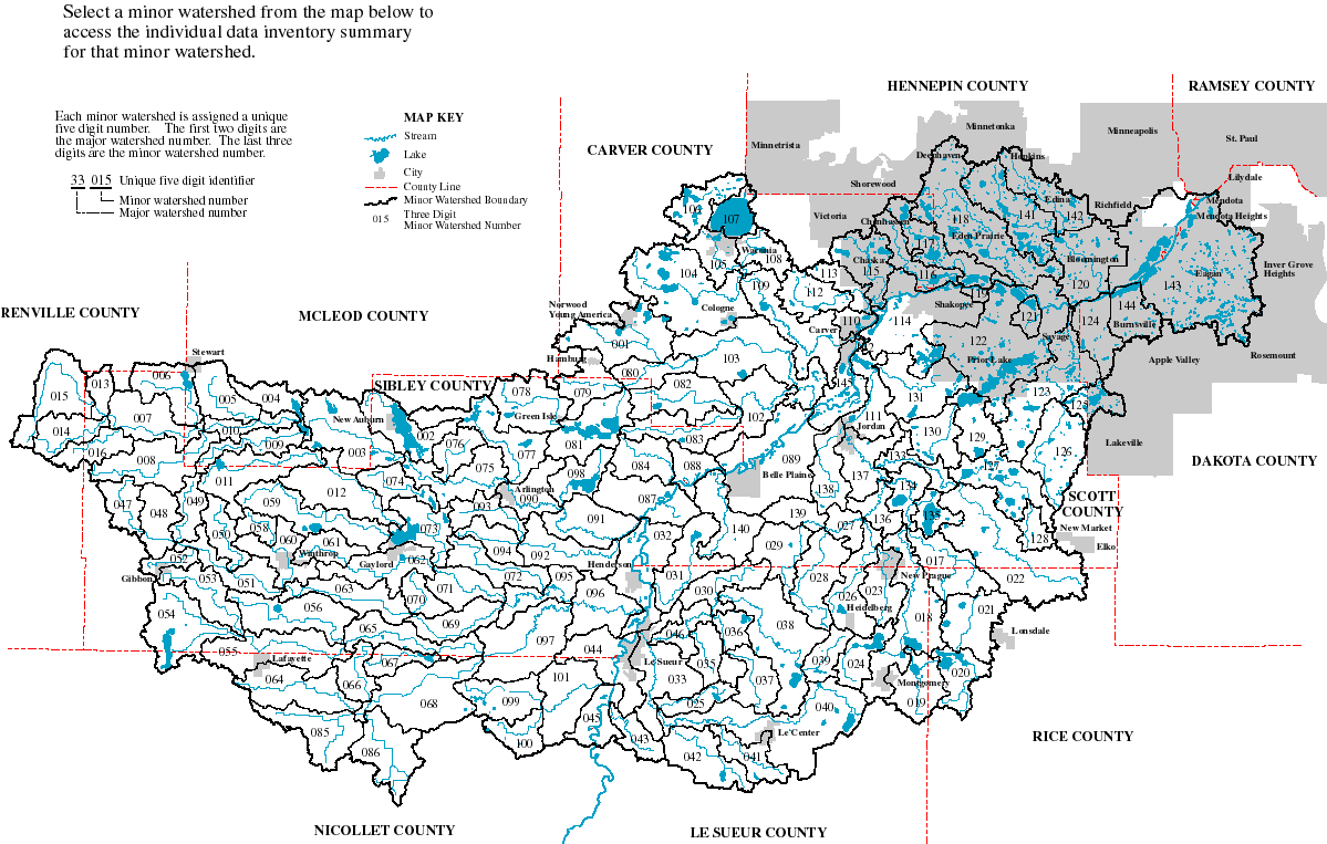
Data inventory summaries for the minor watersheds of the Lower Minnesota River Major Watershed may be accessed by clicking on the minor watershed location in the map below or by selecting the minor watershed number in the list following the map.

The data inventory is from local, state and federal sources.  The inventory reports available data by category and describes the format, status, date, source and pedigree for available data.  Future development of this site will contain additional data summaries including university research and other sources of data.

The data inventory of the Minnesota River Basin is an ongoing process.  Available data not reported in these inventories may be included by notifying the Minnesota River Basin Data Center.  Please contact MRBDC staff  if you have questions or updated information about data contained at this site.  All comments are appreciated.


Map

This page is currently under construction and will be complete by June 30, 1999.


Select a minor watershed number from the list below to access the data inventory summary for that minor watershed.


33001
33002
33003
33004
33005
33006
33007
33008
33009
33010
33011
33012
33013
33014
33015
33016
33017
33018
33019
33020
33021
33022
33023
33024
33025
33026
33027
33028
33029
33030
33031
33032
33033
33035
33036
33037
33038
33039
33040
33041
33042
33043
33044
33045
33046
33047
33048
33049
33050
33051
33052
33053
33054
33055
33056
33058
33059
33060
33061
33062
33063
33064
33065
33066
33067
33068
33069
33070
33071
33072
33073
33074
33075
33076
33077
33078
33079
33080
33081
33082
33083
33084
33085
33086
33087
33088
33089
33090
33091
33092
33093
33094
33095
33096
33097
33098
33099
33100
33101
33102
33103
33104
33105
33106
33107
33108
33109
33110
33111
33112
33113
33114
33115
33116
33117
33118
33119
33120
33121
33122
33123
33124
33125
33126
33127
33128
33129
33130
33131
33132
33133
33134
33135
33136
33137
33138
33139
33140
33141
33142
33143
33144
33145


Select a different
major watershed


Return to top of page 33001 33003 33002 33004 33005 33006 33007 33008 33009 33010 33011 33012 33013 33014 33015 33016 33017 33018 33019 33020 33021 33022 33023 33024 33025 33026 33027 33028 33030 33031 33032 33033 33035 33036 33037 33038 33039 33040 33041 33042 33043 33044 33045 33046 33047 33048 33049 33050 33051 33052 33053 33054 33055 33056 33058 33059 33060 33061 33062 33063 33064 33065 33066 33067 33068 33069 33070 33071 33072 33073 33074 33075 33076 33077 33078 33079 33080 33081 33082 33083 33084 33085 33086 33087 33088 33089 33090 33091 33092 33093 33094 33095 33096 33097 33098 33099 33100 33101 33102 33103 33104 33105 33106 33107 33108 33109 33110 33111 33112 33113 33114 33115 33116 33117 33118 33119 33120 33121 33122 33123 33124 33125 33126 33127 33128 33129 33130 33131 33132 33133 33134 33135 33136 33137 33138 33139 33140 33141 33142 33143 33144 33145