| |

|
|
|
|
|
| |
|
|
Ice Age - Glacial Advances and Retreats
To understand the present Minnesota River Valley, you have to step back in time when glaciers covered Minnesota. During the ice age, the climate was colder and glacial ice covered a large portion of North America. There were four major periods of glaciation where glaciers advanced and retreated across the landscape.
The most recent glacial advance, called the Wisconsin Glaciation, spanned from about 100,000-10,000 years ago. Throughout the Wisconsin Glaciation, lobes of glacial ice pushed in different directions across Minnesota's landscape. The landscape we see today is dramatically shaped by these glaciers. The map shows the maximum extent of the ice coverage during the last glacial advance (Wisconsin glaciation).
Learn more about the history of glaciers in Minnesota
Map adapted from Richard W. Ojakangas and Charles L. Matsch's Minnesota's Geology. University of Minnesota Press, Minneapolis, 1982.
|
|
|
 |
Lake Agassiz
About 12,000 years ago, the glaciers melted back to the topographic divide (near the North Dakota/South Dakota border). Glacial meltwater was trapped and accumulated, creating Lake Agassiz. To get an idea of the immense size of Lake Agassiz, it was bigger than all of the present day Great Lakes combined.
The map shows the total area covered by Lake Agassiz (about 123,500 square miles). It had a maximum depth of about 400 feet. The borders of the lake changed with the shifting ice margins so the lake was never this large at any one time.
Map adapted from John Tester's Minnesota's Natural Heritage. University of Minnesota Press, Minneapolis, 1995.
|
|
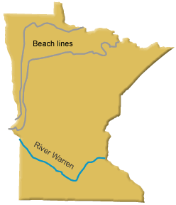 |
River Warren
Lake Agassiz drained in a variety of directions over the years. From 11,500-11,000 and 9,900-9,200 years ago, Lake Agassiz drained through the Minnesota River Valley. Lake Agassiz overtopped a moraine dam (near present day Browns Valley) and an outlet river was created. This outlet, called Glacial River Warren, drained south and carved the Minnesota River Valley. The drainage shifted to Hudson Bay about 8,500 years ago.
Map adapted from Richard W. Ojakangas and Charles L. Matsch's Minnesota's Geology. University of Minnesota Press, Minneapolis, 1982.
|
|
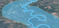 |
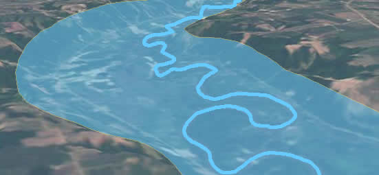
River Warren
This diagram illustrates the scale of the mighty River Warren. The torrent of water that flowed out of Lake Agassiz carved out the large Minnesota River Valley that spans up to five miles across in some places (scroll over image for labels). A huge volume of water filled the valley from bank to bank.
Note the present day Minnesota River is comparatively tiny, shown meandering through the large valley carved by mighty Glacial River Warren.
|
 |
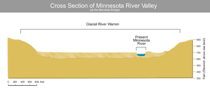
Cross Section of River Warren and Present Minnesota River
This cross section of the Minnesota River at the Mandota Bridge illustrates the small size of the modern Minnesota River compared to the scale of the massive River Warren.
Graphic adapted from Edmund Bray's Billions of Years in Minnesota: The Geological Story of the State. Science Museum of Minnesota, St. Paul, 1980. |
References:
Bray, Edmund. Billions of Years in Minnesota: The Geological Story of the State. Science Museum of Minnesota, St. Paul, 1980.
Ojakangas, Richard W. and Charles L. Matsch. Minnesota's Geology. University of Minnesota Press, Minneapolis, 1982.
Tester, John. Minnesota's Natural Heritage. University of Minnesota Press, Minneapolis, 1995. |
|
This page was last updated 11/15/04
|