|
STATE OF THE MINNESOTA RIVER
EXECUTIVE SUMMARY
SURFACE WATER QUALITY MONITORING 2001
Download a printable and more detailed pdf of this Executive Summary (pdf 2,296 k)
More on how to download and view pdf files
Access the full State of the Minnesota River Report
and Monitoring Map
|
|
Basin Overview
Monitoring
Methods
Precipitation & Runoff
TSS
Nitrate-N
Phosphorus & Orthophosphorus
Considerations
For More Information
|
|
| |
This executive summary provides an overview of the more detailed report entitled State of the Minnesota River: Summary of Surface Water Quality Monitoring 2001. This report summarizes surface water quality monitoring information collected in 2000 and 2001. You can access the full report on the Minnesota River Basin Data Center website at http://mrbdc.mnsu.edu
The Minnesota River has been cited as one of the most polluted rivers in the state and nation. In response to these pronouncements, considerable attention and support have been given to clean up efforts. In order to determine whether these efforts have been successful, it is necessary to measure their effect on the river’s health. This report, a cooperative venture of multiple state and local organizations, begins the task of assembling water quality data and creating a foundation for gauging progress toward a cleaner Minnesota River.
|
| BASIN OVERVIEW |
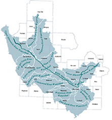 |
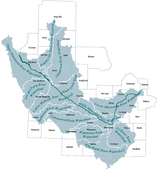
The Minnesota River flows more than 335 miles from its source at Big Stone Lake to its confluence with the Mississippi River at Fort Snelling. It winds through diverse landscapes and drains nearly 20 percent of Minnesota (nearly 16,770 square miles). The watershed is dominated by agricultural land use, primarily in corn and soybean production. As the river nears the metropolitan area, the basin is characterized by more densely settled urban landscapes. The basin is subdivided into 13 major watersheds and includes 37 counties. Many water quality challenges relate to land uses including agricultural runoff and urban point-source discharges. While promising strides have been made to reduce point-source pollutants (like industrial and wastewater treatment plants), managing the array of nonpoint-source inputs marks the challenge ahead.
Monitoring History
State and federal agencies have collected water quality data at various locations and at various times throughout the Minnesota River Basin over the past thirty years. The most comprehensive study of water quality in the Minnesota River Basin, the 1994 Minnesota River Assessment Project (MRAP), concluded that the Minnesota River is impaired by excessive nutrient and sediment concentrations. Particularly in spring and summer, water quality often is impacted by elevated levels of suspended sediments, nitrate-nitrogen, and phosphorus. Previous studies found that the Minnesota River violated standards for bacteria, turbidity, dissolved oxygen, and ammonia. Since the publication of MRAP, several organizations throughout the basin have taken responsibility for collecting additional data to better assess water quality in tributary streams and the Minnesota River mainstem. The State of the Minnesota River: Summary of Surface Water Quality Monitoring 2001 marks the second year water quality data from across the basin was compiled into a summary report. The 2001 full report consolidates and compares both 2000 and 2001 monitoring season data.
|
| MONITORING |
|
|
Monitoring Locations
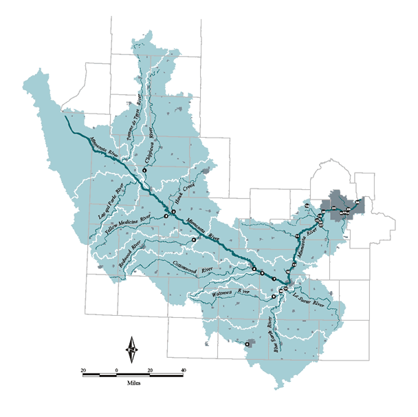
Monitoring site locations for 2001 are illustrated on the map at left. The 2001 report includes 26 monitoring sites, a notable increase from 10 sites included in the 2000 report. These sites are organized and reported according to mainstem, major tributaries and minor tributaries. Four sites are located on the Minnesota River mainstem, eleven are located near the mouths of major tributaries, and eleven are located on minor tributaries. Organizing the sites in this manner allows comparisons streams and rivers of similar size.
Monitoring Season
Monitoring season is based on the portion of the year when the majority of flow occurs. For 2001, monitoring season length was April 1–September 30 while year 2000 extended from April 1–October 31. Monitoring data were gathered by Clean Water Partnership Projects (administered by the Minnesota Pollution Control Agency), Metropolitan Council Environmental Services, and the Minnesota Department of Agriculture (see list of contributors).
Monitoring Focus
This monitoring summary focuses on the primary pollutants of concern in the basin—excessive sediment, phosphorus, orthophosphorus, nitrate-nitrogen, and pesticide concentrations. Previous studies found that the Minnesota River violated standards for bacteria, dissolved oxygen, and ammonia. In accordance with the Clean Water Act, the Minnesota Pollution Control Agency (MPCA) lists rivers and creeks within the basin that have been designated as “impaired waters” due to pollution problems such as low dissolved oxygen, mercury, PCBs, fecal coliform, turbidity, and excess ammonia (http://www.pca.state.mn.us/water/tmdl.html). The Department of Health tracks PCB and mercury levels in fish and issues site specific fish consumption advisories (http://www.health.state.mn.us/divs/eh/fish/index.html).
|
| METHODS |
| |
Methods
Because this report is a joint venture of many agencies and organizations, water quality data collection efforts and data processing methodologies vary somewhat. Organizations involved in the preparation of this report are moving toward a standard set of methods, a step that will further improve the accuracy of water quality comparisons across the basin. In the process of developing this report, specific monitoring criteria were developed that will guide monitoring organizations towards common methodologies (see full report).
Concentrations & Loads
The full report employs and explains many calculations used to describe water quality such as load, yield, and concentrations. This executive summary focuses on two of these calculations—flow-weighted mean concentration (FWMC) and load. FWMC is calculated by dividing the total load (mass) by the total flow or volume. It refers to the concentration (mg/L) of a particular pollutant taking into account the volume of water passing a sampling station over the entire sampling season. In other words, if all of the water passing a monitoring site was put in a large pool, mixed well, and a sample collected, this sample would represent the FWMC. A load is the total amount (mass) of a pollutant coming out of a watershed or passing a location over a given interval of time.
|
| PRECIPITATION & RUNOFF |
 |
Precipitation & Runoff
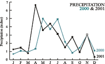
Across the basin, the amount of precipitation varies
geographically, seasonally, and from year to year. In general, the eastern portion of the basin receives more rain than the western. In 2001, total precipitation ranged from 24 to more than 36 inches in parts of the Greater Blue Earth Basin (Watonwan, Blue Earth, and Le Sueur Watersheds). During 2001 spring flooding occurred throughout the Minnesota River Basin (see precipitation graph at right). According to the United States Geological Survey (USGS), record-setting flows were noted at three continuous streamflow gaging stations in the basin. The four main factors contributing to the flood were high autumn precipitation, heavy winter snowfall, sudden snowmelt conditions, and record-breaking April precipitation.
Typically, the more precipitation that occurs in a watershed, the more runoff there will be. However, factors such as soil type, slope, and land use can affect runoff. Evaluating runoff allows for a relative comparison of the amount of water coming out of different individual watersheds or portions of the basin. Higher runoff generally results in higher pollutant loads for most nonpoint source pollutants. The annual runoff graph illustrates the trend of increasing runoff volume over the past several decades.
In 2001, higher runoff resulted in substantial increases in the loads of suspended solids, nutrients and pesticides in almost all of the monitored watersheds. Although loads were larger, a unique set of conditions resulted in lower concentrations of some pollutants of interest. Despite high rainfall in many areas, April flood flows on the mainstem of the Minnesota River contained relatively low concentrations of sediment. During some periods, water clarity was good to excellent for the Minnesota River.
|
| TOTAL SUSPENDED SOLIDS (TSS) |
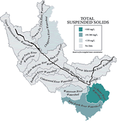 |
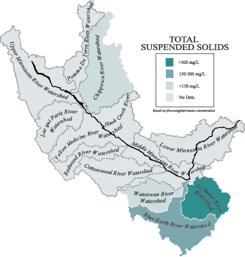
Total Suspended solids (TSS)
Total suspended solids (TSS) is a major water quality concern in the Minnesota River (see box below). The
amount of sediment that enters and is transported through the streams and rivers of the Minnesota River Basin varies greatly from year to year. High runoff years, like 2001, can substantially increase sediment loads. The wide fluctuation in annual delivery is exemplified in the significant increase in TSS loads between 2000 and 2001. Due to increased runoff, the total TSS load of the Minnesota River at Fort Snelling nearly doubled from 728,000 tons in 2000 to 1,411,000 tons in 2001.
Criteria/Standard
It is difficult to find a single agreed-upon value indicating a desirable or acceptable TSS concentration for streams and rivers in the Minnesota River Basin. The State of Minnesota has not established a numeric water quality standard for TSS, but one has been established for turbidity which is an indicator of water clarity. To meet water quality standards, turbidity levels must be no greater than 25 nephelometric turbidity units (NTUs). According to the MPCA, 25 NTUs is approximately equivalent to 58 to 66 mg/L of total suspended solids. As the chart at right indicates, all Minnesota River mainstem and major tributary sites, with the exception of the Chippewa River, exceeded this target during the 2001 monitoring season.
2001 TSS Findings
* Almost all mainstem and major tributary flow-weighted mean concentrations exceeded the target TSS concentration level.
* Largely due to the increased runoff from 2000 to 2001, loads for
total suspended solids (TSS) were dramatically higher for most of
the major tributaries and mainstem sites. The flow-weighted
mean concentrations, however, were typically lower, suggesting different concentration/flow dynamics between the years.
* Relatively low TSS concentrations (<100mg/L) were documented in 2001 during snowmelt-related flood flows on the Minnesota River at Judson and Jordan.
* The TSS loading estimates presented in this report indicate a 37 and 33 percent reduction in load between the Minnesota River at St. Peter and further downstream at Jordan during 2000 and 2001, respectively.
* Although the Greater Blue Earth River Watershed represents only 21 percent of the Minnesota River Basin, the loading data presented in the full report suggest that it contributes a disproportionately large load of TSS and nutrients to the Minnesota River.
|
| NITRATE-NITROGEN & PESTICIDES |
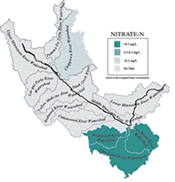 |
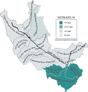
Nitrate-Nitrogen (Nitrate-N)
Nitrate-nitrogen loading in the Minnesota River Basin has local and national implications. At times, some communities in the basin have experienced elevated nitrates in their drinking water. Further downstream, Nitrate-N from the Mississippi River Basin has been identified as one of the major causes for the expanding area of low dissolved oxygen or hypoxia zone in the Gulf of Mexico. Elevated Nitrate-N in the Minnesota River contributes to the hypoxia zone. Nitrate-N is important because it is biologically available to aquatic plants and is a major contributor to the nutrient enrichment of surface waters. Elevated nitrate concentrations in river systems also have the potential to impact water supply wells (see box).
Criteria/Standard
Nitrate-N concentrations in drinking water supplies are a public health issue. The standard for drinking water is 10 mg/L. Average ecoregion values for minimally impacted rivers in the Minnesota River Basin can be applied for Nitrate-N concentrations. Ecoregions are areas with similar physical landscape characteristics. The ecoregion target includes Nitrate-N concentrations in the 0.9 to 6.5 mg/L range.
2001 Nitrate-N Findings
* As indicated in the chart at right, the mainstem of the Minnesota River was generally below the target concentration level with the dramatic exception of the Greater Blue Earth system. This correlates with the relatively higher Nitrate-N concentrations in the Watonwan, Le Sueur, and Blue Earth watersheds.
* Due to increased runoff, Nitrate-N loads for the 2001 monitoring season were significantly higher for mainstem and major tributary sites. The Minnesota River at Jordan, for example, indicates Nitrate-N loads jumping from 15,762 tons in 2000 to 65,308 tons in 2001.
Pesticides
The full report also summarizes pesticide samples collected at three monitoring sites (the mainstem at Judson and Le Sueur and the Blue Earth River). The herbicides metolachlor, atrazine, and acetochlor were the most frequently detected compounds during both 2000 and 2001. These herbicides are typically applied to corn and soybean fields for general weed control. In 2001, metolachlor was found in approximately 92 percent of the samples collected. Acetochlor and atrazine were detected in 71 and 69 percent of the samples, respectively.
|
| PHOSPHORUS & ORTHOPHOSPHORUS |
 |
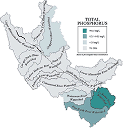
Phosphorus
Phosphorus has been identified as a major pollutant of the Minnesota River. Elevated phosphorus levels is one of the main reasons the Minnesota River is considered one of the most polluted rivers in the state. Controlling phosphorus is an important part of protecting the river.
Criteria/Standard
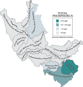
There is growing interest in establishing phosphorus standards for rivers and streams across the nation. In the Minnesota River Basin, this interest is due to phosphorus-induced algal blooms that can lead to turbidity and dissolved oxygen depletion. The Lower Minnesota River Total Maximum Daily Load Study is being conducted to determine the extent of phosphorus reductions needed to protect the lower reach of the river at low flow. The chart at right shows total phosphorus flow-weighted mean concentrations for mainstem and some major tributaries. These values can be compared to the annual average total phosphorus concentrations from 1976-96 for the Mississippi River (0.10 mg/L) and the St. Croix River (0.05 mg/L).
2001 Phosphorus Findings
* Total phosphorus loads in 2001 far exceeded loads in 2000 due to a substantial increase in runoff. For example, total phosphorus loads on the mainstem at St. Peter jumped from 1,112 tons in 2000 to 3,188 tons in 2001.
* The Greater Blue Earth River Basin contributes a large share of the mainstem load and the year-to-year increase in load. The total phosphorus load for the Blue Earth River Watershed increased from 223 tons in 2000 to nearly 1,000 tons in 2001.
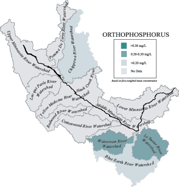
ORTHOPHOSPHORUS
Orthophosphorus, or soluble reactive phosphorus, is the primary form of phosphorus used by algae or other aquatic plants. Therefore, it provides a measure of the phosphorus immediately available for plant growth. Total phosphorus, by contrast, is a measure of the total concentration of phosphorus present in a water sample. The availability of phosphorus in streams, soils and sediments changes in response to a variety of environmental conditions. Because of its availability for uptake by aquatic plants, orthophosphorus is of particular concern for rivers and lakes.
2001 OrthoPhosphorus Findings
* Orthophosphorus flow-weighted mean concentrations were higher during the 2001 monitoring season, particularly during the flood period. This may be due to increased contact between runoff water and the soil surface.
* The chart below illustrates the ratio of orthophosphorus to total phosphorus for 2000 and 2001. In the high-flow year, 2001, a much larger proportion of the total phosphorus was composed of orthophosphorus due to flood dynamics compared to the drier year 2000.
* Orthophosphorus loads increased substantially from 2000 to 2001—from four-fold to greater than twenty- fold. Because orthophosphorus is readily available for biological uptake, loads of this magnitude could have a substantial impact on downstream receiving waters such as Lake Pepin.
|
| CONSIDERATIONS |
| |
Year 2001 – Spring floods & high pollutant loads
Early spring conditions in 2001 included a large snowpack, heavy spring rains, record-setting flows and flooding throughout the Minnesota River Basin. Higher precipitation rates resulted in higher runoff, flows and high loads of pollutants of concern. Loads vary greatly with the river’s flow, and high loads are typical in high-flow years. Understanding water quality impacts on an annual basis helps to characterize problem areas and target solutions. Due to this interagency monitoring effort, much was learned about the water quality impacts of the 2001 flood event. Examining the contribution of minor tributaries and major tributaries provides a richer understanding of the geographic variation across the basin. In 2001, the Greater Blue Earth River Basin (Watonwan, Blue Earth and Le Sueur River Watersheds) stands out as the major source of sediment and nutrient loads to the Minnesota River. However, the two years of data presented in the report demonstrates the great variability in pollutant loads from year to year and reinforces that a long term perspective is key to understanding the true state of the river.
Water Quality Trends
The Minnesota Pollution Control Agency (MPCA) took a long-term view in their recently published report Minnesota River Study Shows Reductions in Key Pollutants. The study examined pollution concentrations from samples collected on the Minnesota River from 1976-2001. Over this time period, the study found approximately 30-40 percent reductions in biochemical oxygen demand, total phosphorus, and total suspended solids concentrations. Although long term trends show improvements, few statistically significant trends were found between 1992-2001 due to limited sampling data and the great variability in pollutant concentrations seasonally and annually. The MPCA report can be accessed at http://www.pca.state.mn.us/water/basins/mnriver/publications.html
Downstream Impacts – Lake Pepin & the Dead Zone
Despite long term improvements, there is still more to be done. Downstream water quality impacts pose a significant concern. When the Minnesota River joins the Mississippi River, it carries excess nutrients and sediment. Therefore, the Minnesota River contributes to the broader Mississippi River water quality problems, specifically in Lake Pepin and the Northern Gulf of Mexico.
Elevated phosphorus and sediment are a particular concern for Lake Pepin. The lake is filling in at a quicker-than-natural pace due to large sediment loads depositing on the lake bed. Lake Pepin also has had a problem with excessive algae blooms during low-flow years due to elevated phosphorus levels, some of which have resulted in fish kills. Further downstream, where the Mississippi drains into the Gulf of Mexico, excess nitrogen from the Minnesota River contributes to low-oxygen problems that impact aquatic life. Researchers have estimated that the Upper Mississippi Watershed contributes more than 30 percent of the annual Nitrogen load to the Mississippi. The zone of hypoxia or dead zone is an area devoid of marine life stretching from the Mississippi River to as far as Texas. Each summer excess nutrients trigger massive algal blooms which result in decreased dissolved oxygen levels. When oxygen in the water is depleted, fish, shrimp and other species can’t survive. Local economies dependent upon these resources are crippled.
Future Challenges
Two major challenges are 1) securing funds for long term monitoring that allows us to evaluate trends; and 2) developing standards for acceptable concentrations of total phosphorus and nitrates in rivers. A number of collaborative partnerships, as exemplified in this water quality study, are fostering a better understanding of the river system and a way to measure progress of the clean up. This water quality information is being used to target implementation practices that reduce pollution, thereby improving the overall health of the river. If you would like to learn more or get involved, please contact the contributors listed on the back cover or log on to the Minnesota River Basin Data Center website at http://mrbdc.mnsu.edu
|
| FOR MORE INFORMATION |
| |
Contributors
Barr Engineering
Brown-Nicollet-Cottonwood Water Quality Board
Chippewa River Watershed Project
Hawk Creek Watershed Project
High Island Creek Watershed Assessment Project
Martin County Environmental Services
Metropolitan Council Environmental Services Program
Minnesota Department of Agriculture Monitoring and Assessment Program
Minnesota Pollution Control Agency, Mankato Office
Redwood-Cottonwood Rivers Control Area
Watonwan River Clean Water Project
Water Resources Center: Minnesota State University, Mankato
Yellow Medicine River Watershed District
Contact Information
Minnesota River Basin Data Center:
Water Resources Center,
Minnesota State University, Mankato
Website: mrbdc.mnsu.edu
Phone: 507-389-5492
Minnesota Pollution Control Agency
Website: www.pca.state.mn.us
Metropolitan Council Environmental Services
Website: www.metrocouncil.org/environment/RiversLakes/
Minnesota Department of Agriculture
Website: www.mda.state.mn.us
University of Minnesota:
Department of Soil, Water, and Climate
Website: www.soils.agri.umn.edu/research/mn-river/
|
|
This page was last updated 12/1/03
|