Minnesota River Virtual Tour - Downstream
|
|
|||||||
|
Stop 12 - Downstream: the Mississippi River |
|||||||
 |
 |
||||||
 |
|||||||
|
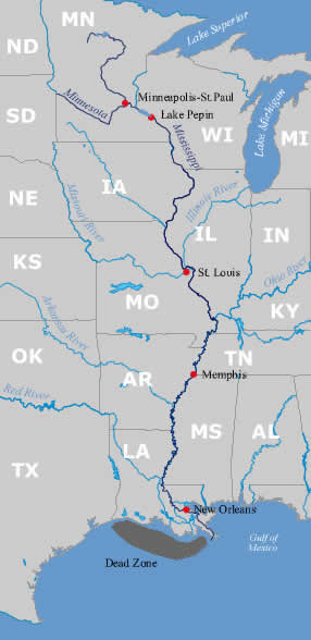
Downstream Impacts Although our canoe journey down the Minnesota River ends when it meets the Mississippi River, the water flows on. If you kept heading downstream on the Mississippi River you would eventually end up in the Gulf of Mexico. The Mississippi River drains 40 percent of the US and flows downstream past cities such as St. Louis, Memphis, and New Orleans. Unfortunately, poor water quality in the Minnesota River contributes to problems downstream, particularly in Lake Pepin and the Gulf of Mexico's Dead Zone. |
|||||||
|
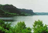
Lake Pepin Lake Pepin (photo at right) is a large natural compoundment of the Mississippi River 50 miles downstream from the Twin Cities. Lake Pepin is experiencing two major problems: increased sediment and increased phosphorus levels. The dominant source of sediment comes from the Minnesota River and due to this increase in sediment, the lake is filling in. In low-flow years, such as 1988 indicated in the photo, increased phosphorus can lead to excessive algae growth. Phosphorus discharged from the Minnesota into the Mississippi River has been identified as a significant source of Lake Pepin's problem. |
 |
||||||
|
Dead Zone |
 |
||||||
 |
|||||||
| | map | 1 | 2 | 3 | 4 | 5 | 6 | 7 | 8 | 9 | 10 | 11 | 12 | basin overview | home | |
|
||||||
|
I would like to learn more about: | minnesota river basin | watersheds | water quality | contacts | home | |
|||||||